Most Oregon Coast itineraries are built around beaches and viewpoints. This one is built around the stuff that makes you pull over and say "wait, what is that?" A steel ship rusting in the sand. A spruce with no real trunk. A plant that eats bugs. A dinosaur in a rainforest.
The route runs north to south, from the mouth of the Columbia River to the stretch of 101 between Port Orford and Gold Beach. It's about 310 miles of driving and roughly nine hours behind the wheel if you never stopped, which you will. Plan on two nights. Drive times below are routing estimates without traffic or stops; summer weekends and road work can add a lot.
1. The Peter Iredale shipwreck, Fort Stevens State Park
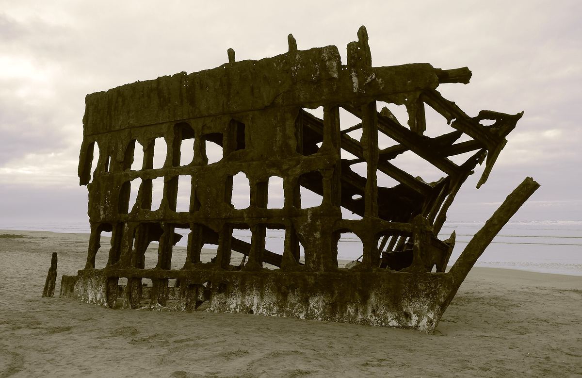
Start at the top. The Peter Iredale was a four-masted steel sailing ship headed for Portland when it ran aground on Clatsop Spit on October 25, 1906. Nobody died, salvage never happened, and more than a century later the bow and a skeleton of ribs are still sitting on the beach at Fort Stevens State Park, near Hammond.
What makes it strange is how casual it is. You park, walk onto the sand, and there it is. At low tide you can walk around it; at high tide the surf washes through the frame.
The park's historic area is worth a detour too: Fort Stevens guarded the Columbia from the Civil War through World War II, and a Japanese submarine shelled it on June 21, 1942.
Good to know: As of October 1, 2025, every day-use area at Fort Stevens requires a day-use parking permit. Buy one at the self-serve kiosks, the museum or the ranger station.
Next leg: Fort Stevens to Cape Meares, about 75 miles, roughly 2 hours through Tillamook and out the Three Capes Scenic Route.
2. The Octopus Tree, Cape Meares
Most people come to Cape Meares State Scenic Viewpoint, about 10 miles west of Tillamook, for Oregon's shortest lighthouse, which is squat and a little adorable. The better oddity is a short walk from the parking lot.
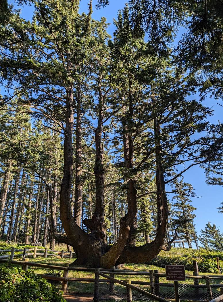
The Octopus Tree is a Sitka spruce with no main trunk. Thick limbs shoot sideways from a broad base and then turn straight up, like a candelabra or an octopus standing on its head. It's thought to be 250 to 300 years old, and one theory says Tillamook people shaped it on purpose.
The trail is about a tenth of a mile each way from the east side of the main lot, past the restrooms. The site is open daily from 7 a.m. to dusk and there's no day-use fee. The lighthouse and its small gift shop were open Thursday through Sunday, 11 a.m. to 4 p.m., when we checked in late September; it closes for the off-season, so check the Friends of Cape Meares Lighthouse site if you want to go inside.
Next leg: Cape Meares to Cape Kiwanda, about 25 miles, 45 minutes on the Three Capes route.
3. Cape Kiwanda and the dory boats, Pacific City
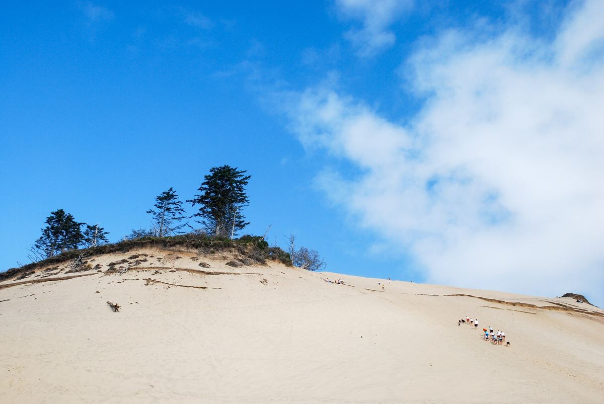
Cape Kiwanda is a sandstone headland on the north edge of Pacific City with a giant sand dune piled against it. People climb the dune for the view, and it's a real workout: steep for the first hundred feet or so, in soft sand.
The oddity here isn't geological. Pacific City is home port to more than 300 dories, flat-bottomed fishing boats that launch straight off the beach into the surf and come back the same way, running up onto the sand at speed. If the fleet is coming in, stay well clear of the landing zone and watch.
Stay behind the fences on top. The sandstone erodes constantly, sinkholes opened near the northwest corner of the dune in 2023, and people have died after climbing over the barriers.
Good to know: Tillamook County runs the parking lot on Hungry Harbor Road and charges a $10 day-use pass. From there it's about a quarter mile on sand to the base of the dune.
Next leg: Pacific City to Otter Rock, about 41 miles, a little over an hour.
4. Devils Punchbowl, Otter Rock
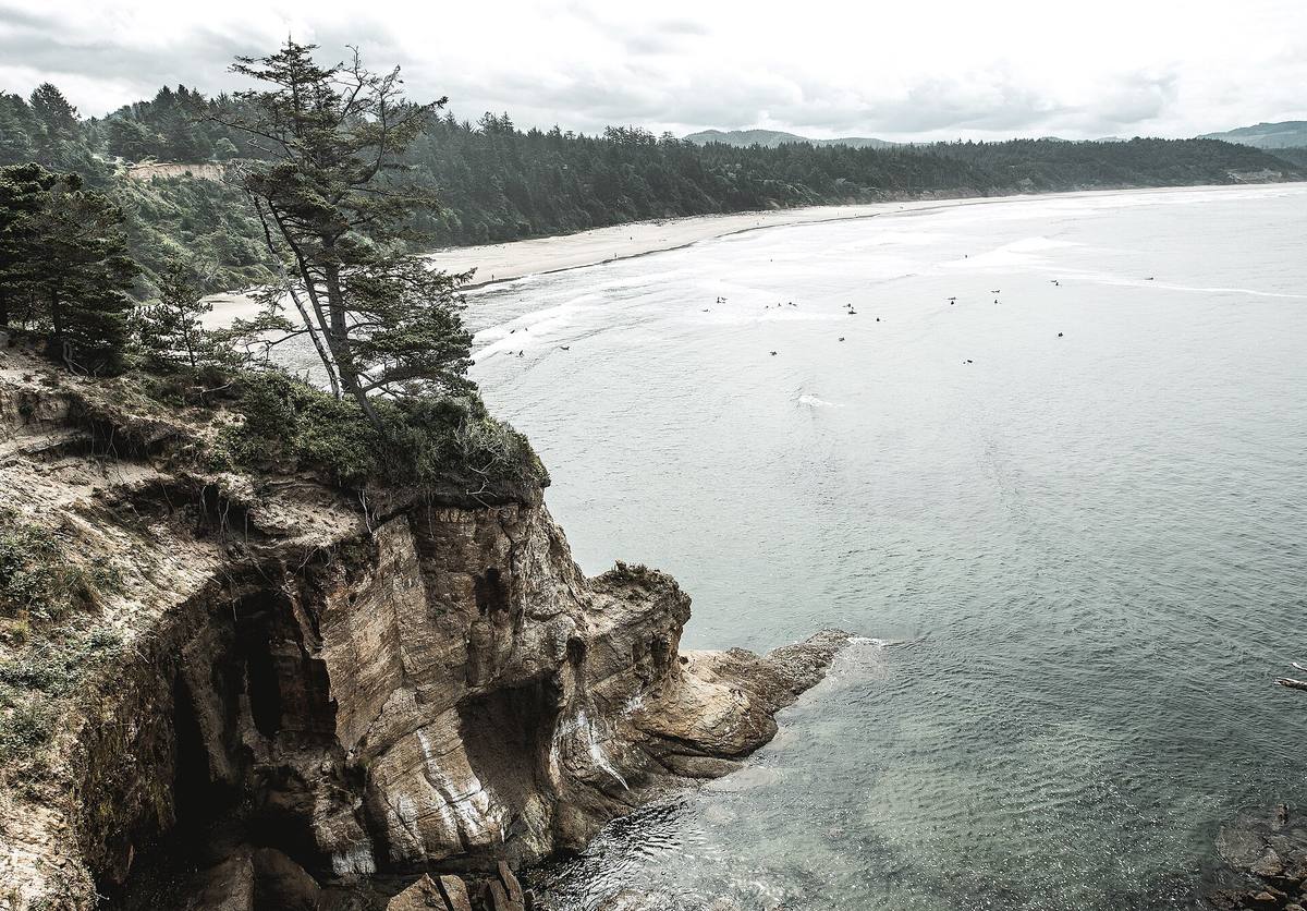
Just north of Newport, take the Otter Crest Loop off 101 to the tiny community of Otter Rock. At the end of the road is Devils Punchbowl, a round hollow in the rock that probably formed when the roofs of two sea caves collapsed. In winter storms the ocean pours in through openings at the base and the whole bowl churns and foams.
In calm weather it's quieter, and the tidepools on the north side are worth a look at low tide. An odd bit of history: in the early 1900s a long wooden slide ran from the bluff down to the beach.
Watch from the overlooks, behind the railings. The rocks are slick and the surf is unpredictable, and a visitor died after a fall here in June 2026.
Good to know: Parking is tight and only allowed in marked stalls. State parks posted a notice in August 2026 that the restrooms are closed for repairs.
Next leg: Otter Rock to Cape Perpetua, about 35 miles, just under an hour through Newport, Waldport and Yachats.
5. Thor's Well, Cape Perpetua
South of Yachats, Cape Perpetua's rocky shore has a hole in the rock shelf that looks like a drain for the ocean. Waves wash over it, the hole fills, then water pours back down it. It's most dramatic around high tide with a decent swell.
We've covered Thor's Well in our Oregon unique places guide, so briefly: watch from the higher rocks, never from the edge, and keep your eyes on the water. Sneaker waves are a real thing here.
Next leg: Cape Perpetua to Sea Lion Caves, about 12 miles, 20 minutes.
6. Sea Lion Caves, north of Florence
This one is a classic roadside attraction, open since 1932 and still privately run. You buy a ticket in a building perched on the cliff, walk a paved path down the slope, and take an elevator 208 feet down through the rock into a sea cave. The owners bill it as the largest sea cave in America, and Steller sea lions use it as a haul-out. From a window at the far end you can also see Heceta Head Lighthouse.
The sea lions are wild and come and go, so some visits are louder than others. It smells exactly like you'd expect.
Good to know: Open daily 9 a.m. to 5:30 p.m. (closed Thanksgiving, Christmas Eve and Christmas Day). Adults $18, seniors $17, kids 5 to 12 $12, 4 and under free. No reservations. Expect 37 steps in the building, about 400 yards of walking on 10 to 20 percent grades, and 63 more steps inside the cave to the lighthouse window.
Next leg: Sea Lion Caves to Darlingtonia, about 6 miles, 10 minutes south.
7. Darlingtonia State Natural Site, Florence
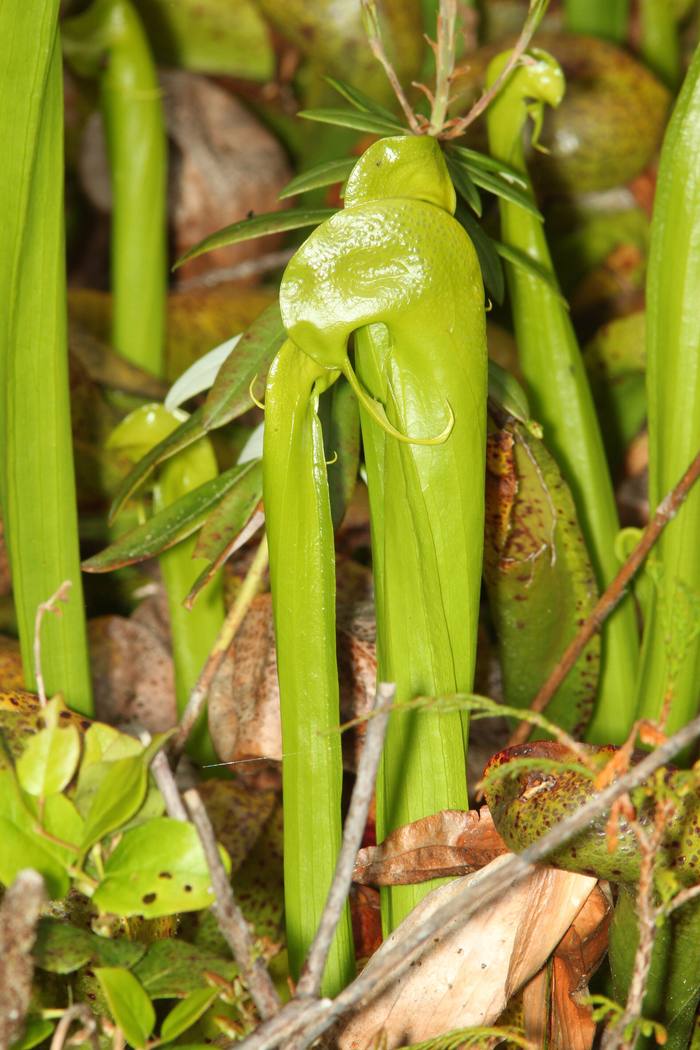
Five miles north of Florence, a small parking lot on the east side of 101 leads to one of the weirdest parks in Oregon. Darlingtonia is the only state park in Oregon set aside to protect a single plant species, and that plant is carnivorous.
The cobra lily (Darlingtonia californica) grows in hooded, yellow-green tubes 10 to 20 inches tall that really do look like snakes rearing up. Insects crawl in after nectar, get fooled by see-through patches that look like exits, and drop into water at the bottom, where they break down and feed the plant. A short path and boardwalk take you out over the fen, where thousands of them grow together. The purple flowers show up in spring.
Good to know: Open year-round for day use, free, with a small picnic area. Picking or collecting the plants is illegal.
Next leg: Darlingtonia to Prehistoric Gardens, about 117 miles, about 3 hours through Florence, Coos Bay, Bandon and Port Orford. This is the longest leg, so break it up.
8. Prehistoric Gardens, between Port Orford and Gold Beach
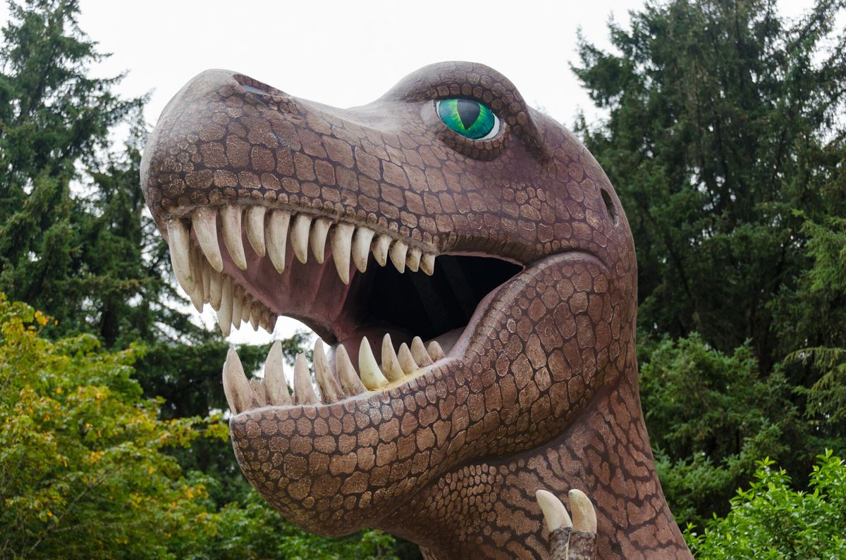
The finale is pure mid-century roadside America. In 1955, E.V. "Ernie" Nelson started building life-size dinosaurs in the rainforest along 101 south of Port Orford. He kept at it for decades, and today 23 of his sculptures stand among the ferns and big trees, including a Brachiosaurus you can see from a long way off down the trail.
It's part kitsch, part wonderful, and the damp green setting does a lot of the work. The trail is about three blocks long and takes around 20 minutes.
Good to know: 36848 US-101, Port Orford. Adults $16, seniors (60+) $15, kids 3 to 12 $12, 2 and under free. Open daily 10 a.m. to 5 p.m. in spring and fall and 9 a.m. to 6 p.m. in summer; call ahead in winter ((541) 332-4463). Strollers aren't allowed on the trail (they lend their own), and only small dogs that can be carried.
Before you go
- Passes and fees: Fort Stevens needs a state parks day-use permit. The Cape Kiwanda lot is $10 (county). Sea Lion Caves and Prehistoric Gardens charge admission. Cape Meares and Darlingtonia are free.
- Tides: The Peter Iredale, the Punchbowl tidepools and Thor's Well all depend on the tide. Oregon State Parks publishes free tide tables.
- The ocean: Don't turn your back on the water, stay off drift logs in the surf and respect every fence.
- Weather: Pack layers and rain gear even in summer. High wind can close the Cape Meares Lighthouse and the Prehistoric Gardens trail.
- Binoculars help with sea lions, seabirds and migrating gray whales: Compact binoculars on Amazon.
- Paper backup: Cell service drops out in stretches. A Benchmark Oregon Road & Recreation Atlas is handy when your map app gives up.
- One detour to skip for now: The Tillamook Air Museum in the giant WWII blimp hangar near Tillamook has been closed since a December 2025 windstorm damaged the roof. Repair work started in September 2026 and the new operator says it hopes to reopen, but check before you go.
Want more of the state? See our Oregon hub and the Oregon scenic road trip.
More Oregon: Oregon state guide · The most unique places in Oregon · Oregon scenic road trip · Oregon places with a haunted reputation · Oregon's most unusual small towns · California's Pacific Coast Highway oddities