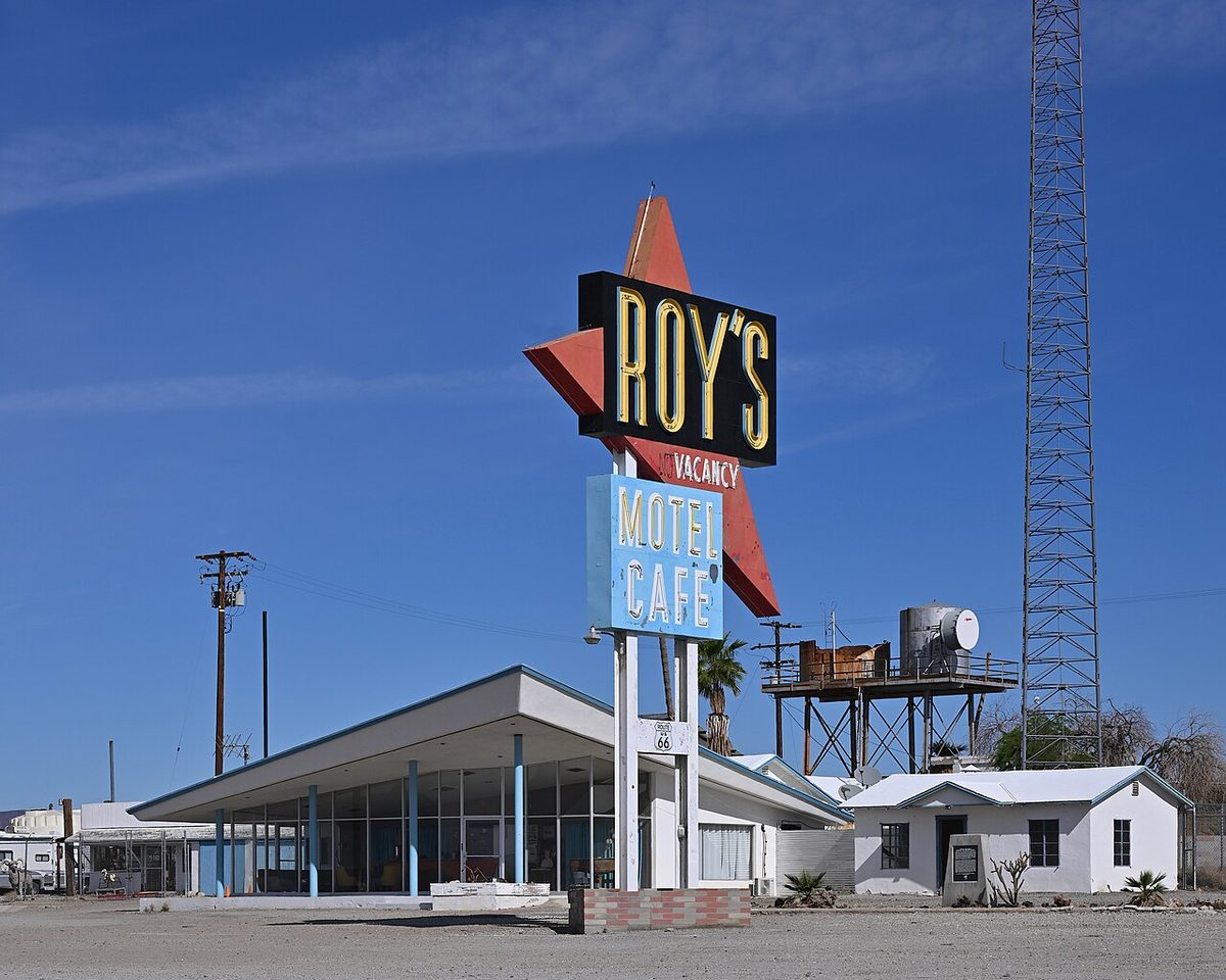
Route 66 turns 100 this year, at least on paper. The federal government named it one of the original numbered highways in November 1926, and California holds the last long stretch before the Pacific. It's also the oddest part of the drive. Somewhere between the Arizona line and the ocean you'll find a boomerang-shaped neon sign over a near-empty desert town, a volcano with a trail to the rim, a forest of welded pipe hung with glass bottles, and motel rooms shaped like teepees.
The eight stops below run east to west, the way most cross-country travelers arrive. We checked each one in early October 2026 against its own website, the agency that runs it, or recent local reporting. Desert hours shift, so call ahead if one stop is the reason you're going.
Start with the road report
In the Mojave, old Route 66 goes by National Trails Highway, and San Bernardino County maintains it. The county's June 30, 2026 update to the San Bernardino Sun lists the road open from Amboy to Kelbaker Road. East of there, Kelbaker Road to Essex and Essex to Mountain Springs Road are closed for bridge work. Many old timber bridges also carry weight limits, some posted for vehicles under three tons, which matters in an RV.
So for 2026, the classic desert run starts at Kelbaker Road. Leave I-40 at the Kelbaker exit, follow it south to National Trails Highway, and head west toward Amboy. It's the same approach the Bureau of Land Management gives for Amboy Crater. Check the county's road-closures page the week you go. Flash floods damaged more than 40 bridges here in August 2014, and one storm can still change the map.
Roy's Motel & Cafe, Amboy
BLM puts Amboy about halfway between Barstow and Needles, roughly 66 miles from each, a tidy number for a Route 66 town. Roy Crowl opened a service station here in 1938. With his son-in-law, Herman "Buster" Burris, it grew into a cafe, garage and motel, and by the late 1940s Roy's ran around the clock. Interstate 40 opened to the north in the early 1970s and took the traffic with it.
The buildings that survived are wonderful. The tall Roy's sign, with its red boomerang arrow, is textbook Googie design, and the slant-roofed lobby with its wall of glass still looks ready for a station wagon full of kids. Albert Okura, founder of the Juan Pollo chicken chain, bought the entire town in 2005 and reopened the gas pumps in 2008. His family is carrying the restoration forward.
This fall you'll find a working gas station and a gift shop with cold drinks, snacks and souvenirs, open daily (current listings show 8 a.m. to about 8:30 p.m.). Meals and motel stays are still on the restoration list; a July 2026 Spectrum News report said the owners hope to have rooms ready by the end of the year. Bring lunch, buy a root beer, and shoot the sign with one eye on traffic.
87520 National Trails Highway, Amboy. (760) 733-1066. visitamboy.com
Amboy Crater: a volcano you can hike
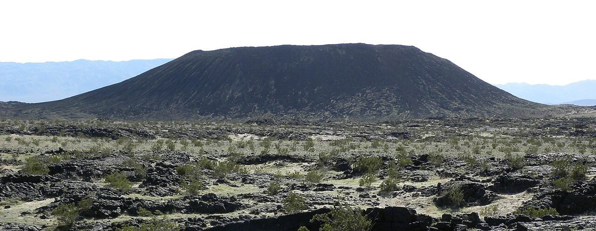
Just west of town, Crater Road leaves National Trails Highway for the dark cone you can see from the road. BLM describes Amboy Crater as a very symmetrical cinder cone, 250 feet high and 1,500 feet across, sitting in one of the youngest volcanic fields in the country. A breach on its west side let basalt pour out across about 24 square miles, leaving lava lakes, collapsed lava tubes and spatter cones. It's been a National Natural Landmark since 1973 and sits inside Mojave Trails National Monument.
The site has paved parking, a vault toilet, shaded picnic tables and a shaded overlook, and BLM's page lists no entry fee. The rim trail has rest stations, and the Twentynine Palms visitor bureau puts it at about three miles round trip. Bring all your water. BLM asks for at least a liter per person plus electrolytes, an early start and a hiking partner. Cell signal is best near the parking lots.
Hike it between late fall and early spring. Summer here can top 120 degrees, and the black rock throws heat back at you, so the overlook is the smart summer choice.
Managed by BLM Needles Field Office: blm.gov
Bagdad Cafe, Newberry Springs
Back on I-40 westbound, exit at Newberry Springs, about 20 miles east of Barstow. Percy Adlon's 1987 film Bagdad Cafe was shot at this A-frame diner, then called the Sidewinder Cafe. Andrea Pruett and her husband bought it in 1995 and gave it the movie's name. The film found its biggest fans in Europe, and tour buses, many of them French, still pull in.
A September 2026 Los Angeles Times story describes walls covered floor to ceiling with visitors' photos and signed dollar bills, and flags from around the world overhead. Pruett died in January 2026 at 85, and her family keeps the doors open. The kitchen has been closed since the pandemic, so treat it as a museum with a souvenir counter, open daily 9 a.m. to 7 p.m. An Airstream trailer sits where one stood in the film.
Route 66 Mother Road Museum, Barstow
Barstow's Harvey House, the Casa del Desierto, is a 1911 Santa Fe depot and hotel ringed with white columns, a California Historical Landmark that still serves as an Amtrak stop. The Route 66 Mother Road Museum closed in June 2024 and has since reopened inside. The cars steal the show, led by a 1958 Edsel and a 1923 Model T doctor's coupe.
The window is short: 11 a.m. to 2 p.m. Monday through Saturday and noon to 3 p.m. Sunday. With extra time, Calico Ghost Town is a short drive away and appears in our California ghost towns guide.
681 N. First Avenue, Barstow. (760) 998-1992. motherroadmuseum.com
Elmer's Bottle Tree Ranch, Oro Grande
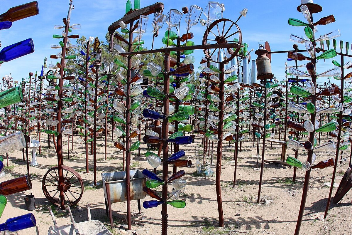
This is the stop people remember. Between Barstow and Victorville, a field beside the highway bristles with welded pipe "trees," each branch capped with a glass bottle and many topped with something odd: an old sign, a wheel rim, a typewriter. Elmer Long, a Marine veteran, started building it around 2000, by his own account. He died in June 2019, and his family keeps the ranch open.
Entry is free, and a donation is a kind gesture. The ranch's site describes hours as roughly dawn to dusk on a semi-regular schedule, with gates sometimes shut during work. Traffic here is fast, so follow the road around the fence to the off-street parking. Plan a restroom stop beforehand, and wear closed shoes for the broken glass and rusty metal at ankle height.
24266 National Trails Highway, Oro Grande. thebottletreeranch.com
California Route 66 Museum, Victorville
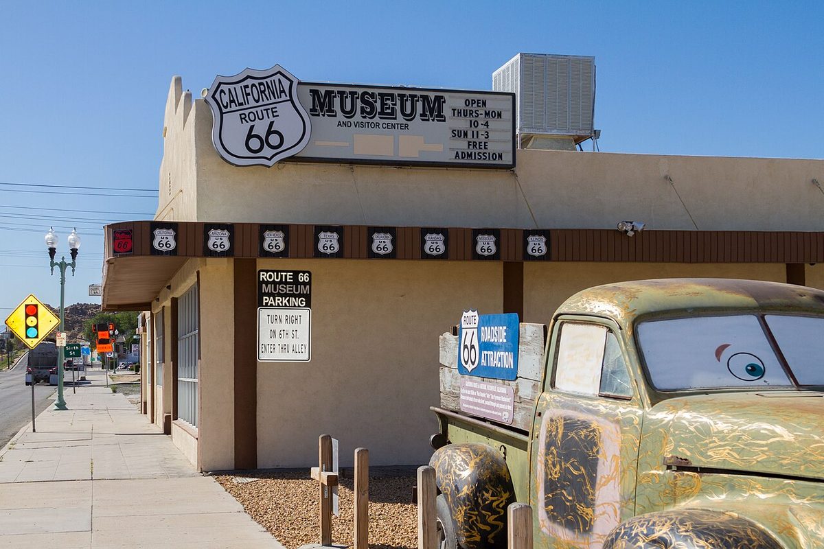
A few miles on, Old Town Victorville's museum packs about 4,500 square feet with road memorabilia. The Victorville Daily Press singled out a 1917 Model T Ford, the first Santa Monica "End of the Trail" booth, and signs from Hulaville, the late Miles Mahan's folk-art yard in nearby Hesperia. Hulaville had bottle trees too, and Route 66 News has suggested it inspired Elmer Long, so the two make a good pair.
Admission is free. Hours are 10 a.m. to 4 p.m. Monday through Saturday and 11 a.m. to 3 p.m. Sunday, with closures on Thanksgiving and over Christmas and New Year's.
16825 D Street, Victorville. califrt66museum.org
Wigwam Motel, San Bernardino
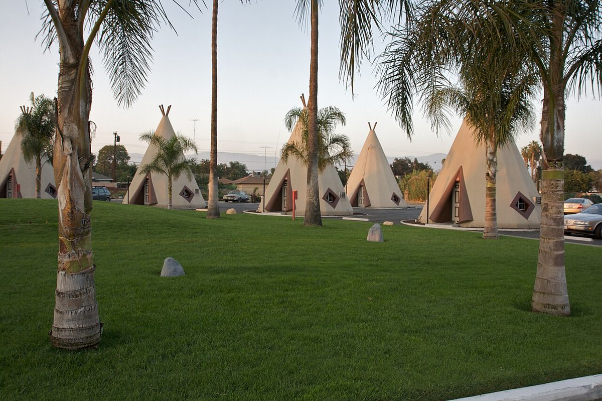
Drop through Cajon Pass to Foothill Boulevard and you'll reach the most famous bed on California's Route 66. Frank Redford, who invented the Wigwam Village idea in Kentucky, built this one himself. It opened in 1950 and grew to 19 rooms, each 32 feet tall, set around a lawn with a small pool. The National Park Service notes the name is a misnomer: the rooms are teepee-shaped, and Redford simply preferred "wigwam."
After years of neglect, the Patel family bought it in 2002 and restored it, and it joined the National Register of Historic Places in 2012. NPS also points out that the Wigwam Villages turn up in Cars as the Cozy Cone Motel. Book a night to sleep in one, or take your photos from Foothill Boulevard and leave the grounds to guests.
2728 Foothill Boulevard, San Bernardino. (909) 875-3005. wigwammotel.com
Santa Monica Pier: the end of the trail
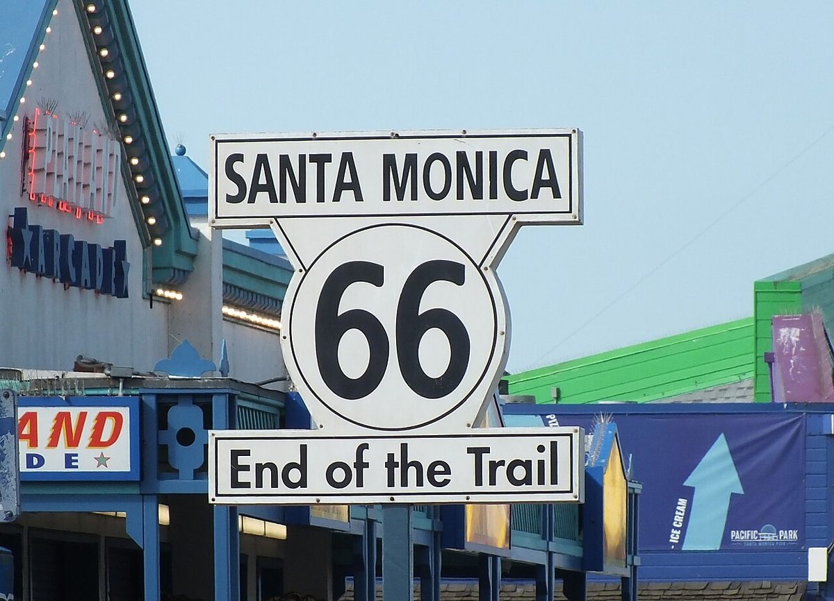
Foothill Boulevard carries the old road west toward Pasadena and Los Angeles, and the trip ends at the ocean. The "Santa Monica 66, End of the Trail" sign on the pier is a replica, dedicated on Veterans Day 2009, the highway's 83rd birthday, in honor of a 1930s sign that stood near Ocean Avenue and Santa Monica Boulevard. Strictly speaking, the official end was inland at Lincoln and Olympic Boulevards, where Mel's Drive-In sits today.
The pier makes the better finish line. Take your photo at the sign, then stop by the city's Visitor Information Center for a free, personalized Route 66 Certificate of Completion.
Visitor info and centennial events: santamonica.com/route66
Before you go
- Check road closures that week. San Bernardino County posts National Trails Highway closures and bridge weight limits. As of the county's summer 2026 update, Amboy to Kelbaker Road is open and the stretch east to Mountain Springs Road is closed.
- Go between late fall and early spring. Summer heat near Amboy can pass 120 degrees, and Amboy Crater has no water on site.
- Fuel up before you leave I-40. Roy's sells gas in Amboy, but start with a full tank. Services are sparse and cell signal fades, so a big insulated water bottle and a paper California road atlas earn their spot.
- Time the museums. Barstow's Mother Road Museum keeps a three-hour daily window, and Victorville closes at 4 p.m. (3 p.m. Sunday).
- Treat private places with care. Roy's, the Bottle Tree Ranch, Bagdad Cafe and the Wigwam Motel are privately run. Shop, donate, or book a room, and leave the grounds as you found them.
Pick the stops that fit your day, carry more water than seems sensible, and save some daylight for that last photo by the Pacific.
Looking for more unusual California trips? Start at our California hub, or see unique places in California, California ghost towns, and our California scenic road trip.
More California: California state guide · The most unique places in California · California scenic road trip · California ghost towns · Yosemite firefall guide · California places with a haunted reputation